
Magnetic inclination and latitude
This activity allows students to determine their magnetic latitude from measurements of the Earth's magnetic field. It develops the understanding of terrestrial magnetism and geographic coordinates.
Activity Summary
The student measures magnetic tilt using the smartphone magnetometer and inclinometer simultaneously in Duo mode. By analyzing the horizontal component of the magnetic field and the angle of inclination relative to the horizontal, the student can calculate their magnetic latitude using a formula and then understand the difference between magnetic and geographic coordinates.
Introduction
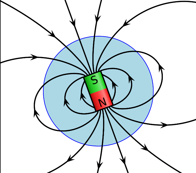
The Earth acts as a giant magnet, with magnetic field lines emerging from the southern magnetic pole, arching through space, and diving back into the northern magnetic pole. The angle at which these field lines intersect the surface, called the magnetic inclination or dip angle, varies systematically with latitude: horizontal at the magnetic equator, vertical at the magnetic poles, and at intermediate angles everywhere else. This relationship was first observed by Georg Hartmann in 1544 and later formalized through the dipole model of Earth's magnetic field. The mathematical formula connecting magnetic inclination I to magnetic latitude λ is remarkably simple: tan(I) = 2 × tan(λ). Using the magnetometer and inclinometer built into every modern smartphone, students can measure the local magnetic field inclination and use this equation to calculate their magnetic latitude, effectively using the Earth's magnetic field as a natural coordinate system. This experiment connects the physics of magnetism with geography and the history of navigation.
Learning Objectives
- Apply the dipole formula tan(I) = 2 × tan(λ) to calculate the magnetic latitude
- Compare the calculated magnetic latitude with the geographic latitude
- Understand the structure of Earth's magnetic field and the concept of magnetic inclination
- Appreciate the difference between magnetic and geographic coordinates
Scientific Concepts
Instruments and sensors
Scientific instruments
- Magnetometer
- Inclinometer
Sensors
- Magnetometer
- Accelerometer
FizziQ Features
- Duo mode — Records the magnetometer and inclinometer simultaneously so the horizontal/vertical field components and the tilt angle are captured at the same instant.
- Experiment notebook — Used to log the measured Bh, Bv and inclination values and to work through the dipole formula when calculating the magnetic latitude.
Required Materials
- - Smartphone or tablet with a magnetic field measurement application (FizziQ) - Environment free from magnetic disturbances - FizziQ experiment notebook - Calculator for trigonometric calculations - Note: the protocol remains adaptable to any comparable magnetic field measurement tool.
Experimental Protocol
Find a location **free from magnetic disturbances**: away from metal structures, electrical cables, electronic devices, and vehicles. An outdoor location in an open field is ideal.
Open FizziQ and select the **Duo mode** to record both the **Magnetometer** (magnetic field components) and the **Inclinometer** simultaneously.
Place the smartphone on a **flat, non-magnetic surface** (wooden table, plastic bench, or directly on the ground away from any metal).
Rotate the phone slowly until the **horizontal component** of the magnetic field is maximized and the phone is aligned with the magnetic meridian (pointing toward magnetic north).
Record the values of the **horizontal (Bh) and vertical (Bv) components** of the magnetic field.
Calculate the **magnetic inclination** I from: tan(I) = Bv / Bh, or read the inclination directly if FizziQ displays it.
Record the inclination angle I in degrees.
Apply the **dipole formula** to calculate the magnetic latitude: **λ = arctan(tan(I) / 2)**.
Convert the result to degrees. This is your **magnetic latitude**.
Look up your **geographic latitude** using a GPS app or map. Compare it with the calculated magnetic latitude.
The two values will differ because the magnetic poles do not coincide with the geographic poles (the current magnetic declination and the non-dipolar components of Earth's field cause discrepancies).
Research the current position of the **north magnetic pole** and discuss why geographic and magnetic latitudes differ.
Expected Results
At a mid-latitude European location (e.g., Paris, 48.9°N), the magnetic inclination is approximately 64-66°, yielding a magnetic latitude of about 47-49° using the dipole formula, which is close to but not exactly equal to the geographic latitude. The discrepancy (typically 2-5°) arises from two factors: the magnetic dipole axis is tilted about 11° from the rotation axis, and the Earth's magnetic field is not a perfect dipole (higher-order components cause local anomalies). The smartphone magnetometer typically measures the field components with a precision of ±1 µT, which translates to an inclination uncertainty of about ±1-2°. Environmental magnetic noise from nearby buildings or vehicles can cause larger errors.
Scientific Questions
- What is the difference between magnetic declination and magnetic inclination?
- Why do the magnetic poles not coincide with the geographic poles?
- How has the position of the magnetic north pole changed over time, and what causes this drift?
- What would the magnetic inclination be at the magnetic equator? At the magnetic poles?
- How did navigators historically use magnetic inclination to estimate their latitude?
Scientific Background
The Earth's magnetic field resembles that of a dipole inclined about 11° relative to the axis of rotation. This configuration explains why the magnetic inclination (angle between the magnetic field and the horizontal) varies with latitude.
At the magnetic pole, the inclination is 90° (vertical field); at the magnetic equator, it is 0° (horizontal field). Between these two extremes, the inclination i can be approximately related to the magnetic latitude L by the formula: tan(i) = 2×tan(L).
This relationship follows from the mathematical model of the Earth's magnetic dipole. The smartphone's magnetometer measures the components of the magnetic field along three axes.
The Y (horizontal) component is maximum when the device is oriented towards magnetic north. The inclinometer measures the angle between the smartphone and the horizontal.
By correctly orienting the device, the local magnetic inclination can be determined. Calculated magnetic latitude generally differs from geographic latitude for two reasons: 1) The offset between the magnetic and geographic poles (the magnetic north pole is currently in the Canadian Arctic, at approximately 86.5°N, 170.9°E); 2) Local magnetic anomalies due to the composition of the subsoil.
These measurements make it possible to concretely understand the three-dimensional structure of the Earth's magnetic field. Historically, the discovery of magnetic inclination is attributed to Georg Hartmann (1544), but Robert Norman was the first to measure it precisely (1581).
The experiment conceptually reproduces that of the explorer James Clark Ross who located the north magnetic pole in 1831 by following variations in inclination.
Extensions
- Create a map of magnetic field strength and direction across the schoolyard
- Compare measurements taken inside a building versus outside to assess the effect of building materials on the magnetic field
- Research the history of magnetic navigation and the search for a method to determine longitude at sea
- Use published global magnetic field models (like IGRF) to calculate the expected inclination at your location and compare with your measurement
Frequently Asked Questions
The magnetic field readings change wildly when I move the phone. How do I get a stable measurement?
Keep the phone perfectly still for at least 10 seconds before recording a value. Magnetic interference from your body (watch, belt buckle, phone case magnets) can affect readings. Remove metal objects from your vicinity and hands.
My calculated magnetic latitude is several degrees off from my geographic latitude. Is the formula wrong?
The dipole formula is an approximation that assumes a perfect centered dipole, which the Earth's field is not. Discrepancies of 2-10° are normal due to the tilt of the magnetic axis and non-dipolar field components.
Can I do this experiment indoors?
Indoor measurements are possible but less reliable. Steel-reinforced concrete, electrical wiring, and electronic equipment create local magnetic fields that can significantly distort the readings. For best results, measure outdoors in an open area.
The inclination I measured seems very different from what I expected. What could cause this?
Check for nearby magnetic sources: large metal objects, permanent magnets, electrical transformers, or underground pipes. Even a car parked 5 meters away can distort the magnetic field enough to affect the inclination by several degrees.
Detailed Description
The student measures magnetic tilt using the smartphone magnetometer and inclinometer simultaneously in Duo mode. By analyzing the horizontal component of the magnetic field and the angle of inclination relative to the horizontal, the student can calculate their magnetic latitude using a formula and then understand the difference between magnetic and geographic coordinates. In FizziQ, the Duo mode displays the magnetometer and inclinometer readings side by side in real time, and the experiment notebook can be used to record the Bh, Bv and inclination values needed to compute the magnetic latitude.
Ready to start?
Download FizziQ and try this activity with your students.